

Pappus Travel Planner
From the plan to the settle-up — everything your trips involve
Depends on a specific server
- Developer
- Calyptra Software
- License
- GPL-3.0-or-later
- Package
dev.calyptra.pappus- Category
- Navigation, Public Transport
- Latest version
- 1.15.0 · Nov 4, 2026
- Minimum Android
- Android 7.0
Screenshots
Description
Plan a trip day by day — where you go, how you get there, and what it costs, broken down by category and by person — and keep the whole database in one portable SQLite file that belongs to you. No account, no server, nothing uploaded. The app works with the network switched off; the exceptions are an optional connection search that looks up real timetables and writes the answer into your local plan, and the map, whose background tiles are fetched while you look at them.
You can plan all kinds of trips: an afternoon out, the daily commute, and two weeks abroad are planned the same way, and differ only in their dates.
Features
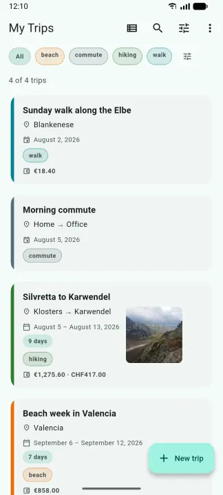
• Trips, organized the way you file them — dates, notes, participants, an accent color, and tags you invent yourself. Search, filter, and sort the overview, or switch it to a month calendar.
• Routines — keep a commute or a weekly ride as a dateless template and stamp it out onto any day, before or after the fact.
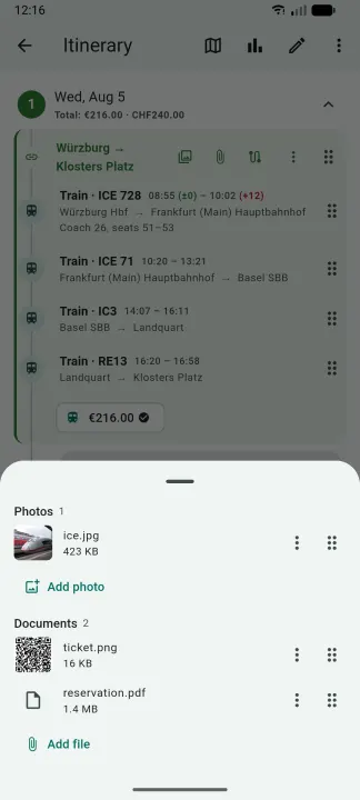
• A day-by-day itinerary of places and transport legs, with optional times, grouping for a shared ticket, and drag-to-reorder.
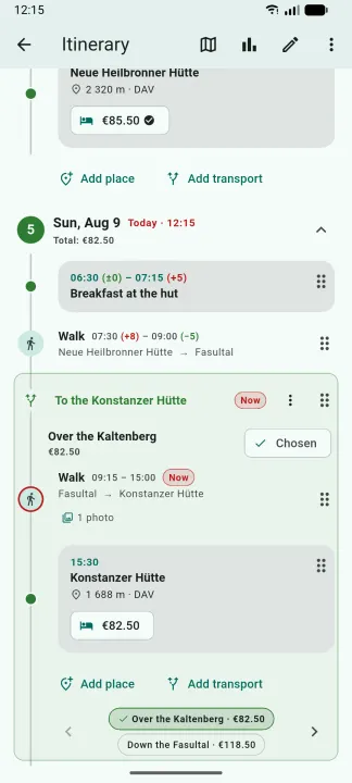
• Alternatives — plan different ways a day could go and pick one later; only the chosen option counts toward the trip's money.
• Planned versus actual times, with a green or red +/− on each end, and a "you are here" mark on today's plan.
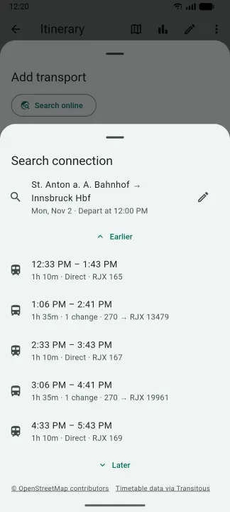
• Real connections — search an open routing service (Transitous) covering public transport, long-distance trains, buses, and more from operators around the world, compare the results, import one as that day's legs, and refresh its live times later.
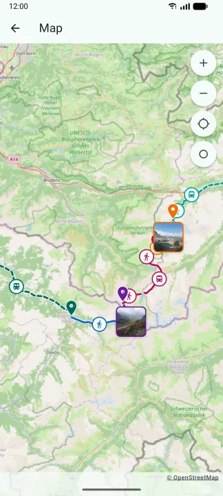
• A map — a trip's places and legs on an OpenStreetMap background, with the entry that is under way marked as the timeline marks it. Record a track from the map, or import a GPX file, and the map draws the line you actually followed instead of the straight one.
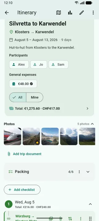
• Photos and files on the plan — attach a photograph or a document to an entry, to a group, or to the trip itself. They live inside the database, so a copy of that one file is a copy of everything. A photo carrying a position shows up on the map, and one of them can be the cover on the trip's overview card.
• Costs in as many currencies as you like — attached to a place, a leg, a whole shared ticket, or the trip, with your own categories and your own exchange rates.
• Countries you have been to — the world drawn from bundled outlines, counted from your trips or entered manually.
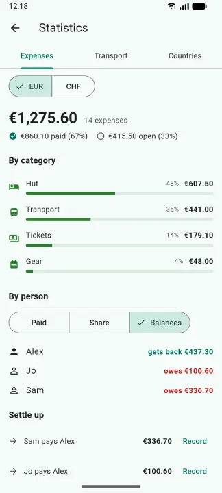
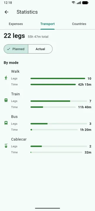
• Statistics — spending by category and by person, and how you actually traveled: legs and time per transport mode, planned against what really happened.
• Settle-up — paid versus fair share, a minimal set of payments to square up, and settlements you can book back once they are paid.
• Checklists per trip, movable and copyable to the next one.
• Share and export — a lossless .tpt bundle for another user of the app (attachments included), a printable PDF with the sections you tick, or an .ics file for whatever calendar you already use.
• An Android home-screen widget — your current or next trip, a countdown, and today's plan with the same delay marks the timeline uses; tapping a row opens that entry.
• English, German, and Chinese, and a light / dark / system theme.
Free and open software under the GPL-3.0-or-later. The same code base also runs on Linux, Windows, macOS, the web, and iOS.
You can plan all kinds of trips: an afternoon out, the daily commute, and two weeks abroad are planned the same way, and differ only in their dates.
Features
• Trips, organized the way you file them — dates, notes, participants, an accent color, and tags you invent yourself. Search, filter, and sort the overview, or switch it to a month calendar.
• Routines — keep a commute or a weekly ride as a dateless template and stamp it out onto any day, before or after the fact.
• A day-by-day itinerary of places and transport legs, with optional times, grouping for a shared ticket, and drag-to-reorder.
• Alternatives — plan different ways a day could go and pick one later; only the chosen option counts toward the trip's money.
• Planned versus actual times, with a green or red +/− on each end, and a "you are here" mark on today's plan.
• Real connections — search an open routing service (Transitous) covering public transport, long-distance trains, buses, and more from operators around the world, compare the results, import one as that day's legs, and refresh its live times later.
• A map — a trip's places and legs on an OpenStreetMap background, with the entry that is under way marked as the timeline marks it. Record a track from the map, or import a GPX file, and the map draws the line you actually followed instead of the straight one.
• Photos and files on the plan — attach a photograph or a document to an entry, to a group, or to the trip itself. They live inside the database, so a copy of that one file is a copy of everything. A photo carrying a position shows up on the map, and one of them can be the cover on the trip's overview card.
• Costs in as many currencies as you like — attached to a place, a leg, a whole shared ticket, or the trip, with your own categories and your own exchange rates.
• Countries you have been to — the world drawn from bundled outlines, counted from your trips or entered manually.
• Statistics — spending by category and by person, and how you actually traveled: legs and time per transport mode, planned against what really happened.
• Settle-up — paid versus fair share, a minimal set of payments to square up, and settlements you can book back once they are paid.
• Checklists per trip, movable and copyable to the next one.
• Share and export — a lossless .tpt bundle for another user of the app (attachments included), a printable PDF with the sections you tick, or an .ics file for whatever calendar you already use.
• An Android home-screen widget — your current or next trip, a countdown, and today's plan with the same delay marks the timeline uses; tapping a row opens that entry.
• English, German, and Chinese, and a light / dark / system theme.
Free and open software under the GPL-3.0-or-later. The same code base also runs on Linux, Windows, macOS, the web, and iOS.
All versions
| Version | Released | Minimum Android | Size |
|---|---|---|---|
| 1.15.0 (3 builds) | Nov 4, 2026 | Android 7.0 | 30.6 MB |
| 1.14.0 (3 builds) | Oct 27, 2026 | Android 7.0 | 30.3 MB |
| 1.13.2 (3 builds) | Oct 22, 2026 | Android 7.0 | 29.6 MB |
How to install an older version of an Android app · How to install an APK file on Android
From the developer (GitHub)
APK files published by the developer on GitHub. They are signed by the developer and may not install over the other builds on this page (different signature). Links open github.com.
v1.15.0
· Oct 31, 2026
app-arm64-v8a-release.apk
29.1 MB app-armeabi-v7a-release.apk
27.5 MB app-x86_64-release.apk
30.6 MB v1.14.0
· Oct 23, 2026
app-arm64-v8a-release.apk
28.9 MB app-armeabi-v7a-release.apk
27.3 MB app-x86_64-release.apk
30.3 MB v1.13.2
· Oct 4, 2026
app-arm64-v8a-release.apk
28.1 MB app-armeabi-v7a-release.apk
26.5 MB app-x86_64-release.apk
29.6 MB Similar apps
-
 RailTrip
Travel through the train stations to stamp your visa!
-
 Tower Collector
Join the community and collect cell towers locations from your area!
-
 OsmAnd~
Global Mobile Map Viewing & Navigation for Offline and Online OSM Maps
-
 Déjà Vu - A local RF based back end for the µg Pro
Mobile/cell and WLAN/Wi-Fi based network provider for UnifiedNlp and microG
-
 CoMaps - Hike, Bike, Drive Offline with Privacy
Easy map navigation - Discover more of your journey - Powered by the community
-
 Organic Maps・Offline Map & GPS
Get reliable offline maps with GPS navigation for hiking, cycling, and travel.
-
 BRouter
Get elevation-aware cycling directions
-
 Sky Map
 turns your phone into a window on the night sky.