

Bluetooth GNSS
Connect your phone to external Bluetooth GPS/GLONASS/Galileo/BeiDou receivers
- Developer
- Kasidit Yusuf
- License
- GPL-2.0-or-later
- Package
com.clearevo.bluetooth_gnss- Category
- Navigation
- Latest version
- 2.1.6 · Aug 19, 2025
- Minimum Android
- Android 8.0
Screenshots
Description
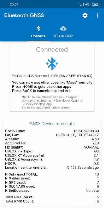
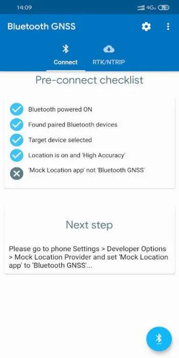
Bluetooth GNSS lets you use accurate satellite positioning from powerful external Bluetooth GPS/Galileo/GLONASS/BeiDou receivers instead of the less powerful internal A-GPS of phones/tablets - for better location accuracy with your favorite Maps and Navigation apps like Google Maps, etc.
You must first get an external Bluetooth GNSS/GPS device like the EcoDroidGPS (www.ClearEvo.com), HOLUX, Garmin GLO, etc to use with this app, which is free and open-source software. If your Bluetooth GNSS/GPS device supports RTK, this app also supports overlay of NTRIP server data streams for professional RTK positioning (centimeter-level accuracy - depends on device).
This app supports showing ’Accuracy’ estimates from the U-Blox ’PUBX’ accuracy messages, instead of the commonly used ’HDOP x CEP’ method. This PUBX accuracy reading exactly matches as is the same source of the ’Accuracy’ as shown in U-Center PC tool when connected directly to the M8030 (EcoDroidGPS) or ZED-F9P (EcoDroidGPS + ArduSimple) devices via USB.
How to test if your target app uses the mock location from this app or not: during a connection, create a file named ’bt_gnss_test_debug_mock_location_1_1_mode_flag’ in internal storage (adb command: touch /sdcard/bt_gnss_test_debug_mock_location_1_1_mode_flag) and see if your target app now shows lat as 1.0 and lon as 1.0 or not, remove/delete the file to resume using real lat lon from connected bluetooth device.
You must first get an external Bluetooth GNSS/GPS device like the EcoDroidGPS (www.ClearEvo.com), HOLUX, Garmin GLO, etc to use with this app, which is free and open-source software. If your Bluetooth GNSS/GPS device supports RTK, this app also supports overlay of NTRIP server data streams for professional RTK positioning (centimeter-level accuracy - depends on device).
This app supports showing ’Accuracy’ estimates from the U-Blox ’PUBX’ accuracy messages, instead of the commonly used ’HDOP x CEP’ method. This PUBX accuracy reading exactly matches as is the same source of the ’Accuracy’ as shown in U-Center PC tool when connected directly to the M8030 (EcoDroidGPS) or ZED-F9P (EcoDroidGPS + ArduSimple) devices via USB.
How to test if your target app uses the mock location from this app or not: during a connection, create a file named ’bt_gnss_test_debug_mock_location_1_1_mode_flag’ in internal storage (adb command: touch /sdcard/bt_gnss_test_debug_mock_location_1_1_mode_flag) and see if your target app now shows lat as 1.0 and lon as 1.0 or not, remove/delete the file to resume using real lat lon from connected bluetooth device.
All versions
| Version | Released | Minimum Android | Size |
|---|---|---|---|
| 2.1.6 | Aug 19, 2025 | Android 8.0 | 23.4 MB |
How to install an older version of an Android app · How to install an APK file on Android
From the developer (GitHub)
APK files published by the developer on GitHub. They are signed by the developer and may not install over the other builds on this page (different signature). Links open github.com.
Similar apps
-
 RailTrip
Travel through the train stations to stamp your visa!
-
 Tower Collector
Join the community and collect cell towers locations from your area!
-
 OsmAnd~
Global Mobile Map Viewing & Navigation for Offline and Online OSM Maps
-
 Déjà Vu - A local RF based back end for the µg Pro
Mobile/cell and WLAN/Wi-Fi based network provider for UnifiedNlp and microG
-
 CoMaps - Hike, Bike, Drive Offline with Privacy
Easy map navigation - Discover more of your journey - Powered by the community
-
 Organic Maps・Offline Map & GPS
Get reliable offline maps with GPS navigation for hiking, cycling, and travel.
-
 BRouter
Get elevation-aware cycling directions
-
 Sky Map
 turns your phone into a window on the night sky.