

TyphoonEye
Typhoon tracks, forecasts and alerts for the Northwest Pacific
Promotes non-free network services
- Developer
- Seamain
- License
- Apache-2.0
- Package
seamain.org.typhoonEye- Category
- Navigation, Weather
- Latest version
- 1.3.3 · Nov 6, 2026
- Minimum Android
- Android 10
Screenshots
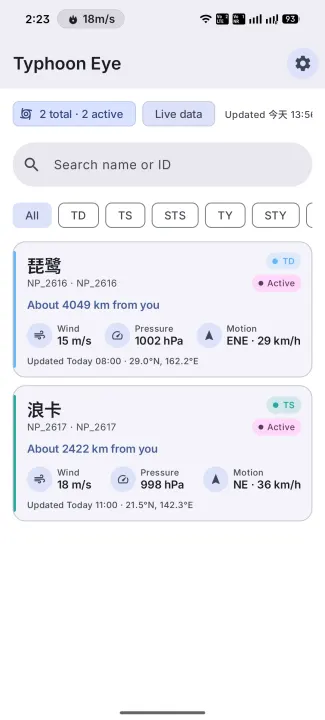
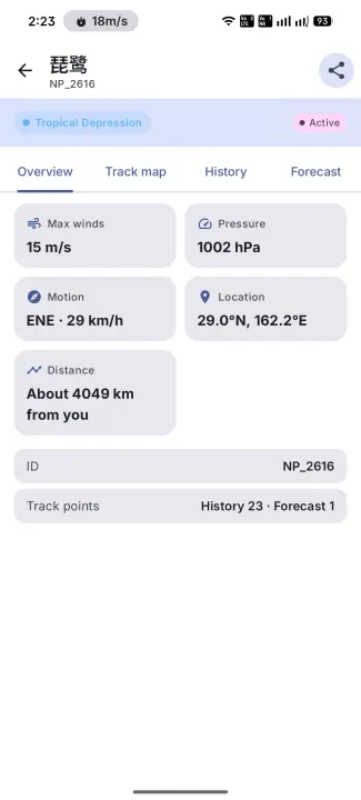
Description
TyphoonEye is a lightweight, open-source real-time typhoon tracking and weather alert app for Android.
Features:
• Live typhoon tracking with interactive MapLibre maps
• Historical tracks, forecast paths, and 7/10/12-level wind radii by quadrant
• Optional distance-based emergency alerts (needs location permission)
• Material Design 3, dynamic color, light/dark theme, multiple languages
• Clearly labeled sample data you can open when live data can't be loaded
Network note:
Typhoon data comes from third-party weather APIs (QWeather / Juhe) and is fetched through TyphoonEye's own relay server on Cloudflare. The API keys live only on the relay; the app contains none. The relay uses your IP address for rate limiting and does not store it. Your location is never sent to the relay: warnings near you are matched on your device and currently cover coastal areas only. Basemap tiles come from OpenFreeMap (OpenStreetMap data). Optional mainland China basemap tiles may use Amap. No ads or analytics.
This is not an official meteorological app. In an emergency, always follow your local meteorological authority.
F-Droid builds update through the F-Droid client (no GitHub APK sideload).
Features:
• Live typhoon tracking with interactive MapLibre maps
• Historical tracks, forecast paths, and 7/10/12-level wind radii by quadrant
• Optional distance-based emergency alerts (needs location permission)
• Material Design 3, dynamic color, light/dark theme, multiple languages
• Clearly labeled sample data you can open when live data can't be loaded
Network note:
Typhoon data comes from third-party weather APIs (QWeather / Juhe) and is fetched through TyphoonEye's own relay server on Cloudflare. The API keys live only on the relay; the app contains none. The relay uses your IP address for rate limiting and does not store it. Your location is never sent to the relay: warnings near you are matched on your device and currently cover coastal areas only. Basemap tiles come from OpenFreeMap (OpenStreetMap data). Optional mainland China basemap tiles may use Amap. No ads or analytics.
This is not an official meteorological app. In an emergency, always follow your local meteorological authority.
F-Droid builds update through the F-Droid client (no GitHub APK sideload).
All versions
| Version | Released | Minimum Android | Size |
|---|---|---|---|
| 1.3.3 (4 builds) | Nov 6, 2026 | Android 10 | 9.7 MB |
| 1.3.2 (4 builds) | Oct 25, 2026 | Android 10 | 9.7 MB |
| 1.3.1 (4 builds) | Oct 12, 2026 | Android 10 | 9.6 MB |
How to install an older version of an Android app · How to install an APK file on Android
From the developer (GitHub)
APK files published by the developer on GitHub. They are signed by the developer and may not install over the other builds on this page (different signature). Links open github.com.
v1.3.4
· Nov 16, 2026
TyphoonEye-v1.3.4-app-github-split-arm64-v8a-release.apk
9.6 MB TyphoonEye-v1.3.4-app-github-split-armeabi-v7a-release.apk
9.1 MB TyphoonEye-v1.3.4-app-github-split-x86-release.apk
9.8 MB TyphoonEye-v1.3.4-app-github-split-x86_64-release.apk
9.8 MB fdroid-1.3.4
· Nov 16, 2026
app-fdroid-arm64-v8a-release-signed.apk
9.6 MB app-fdroid-armeabi-v7a-release-signed.apk
9.1 MB app-fdroid-x86-release-signed.apk
9.8 MB app-fdroid-x86_64-release-signed.apk
9.8 MB Similar apps
-
 RailTrip
Travel through the train stations to stamp your visa!
-
 Tower Collector
Join the community and collect cell towers locations from your area!
-
 OsmAnd~
Global Mobile Map Viewing & Navigation for Offline and Online OSM Maps
-
 Déjà Vu - A local RF based back end for the µg Pro
Mobile/cell and WLAN/Wi-Fi based network provider for UnifiedNlp and microG
-
 CoMaps - Hike, Bike, Drive Offline with Privacy
Easy map navigation - Discover more of your journey - Powered by the community
-
 Organic Maps・Offline Map & GPS
Get reliable offline maps with GPS navigation for hiking, cycling, and travel.
-
 BRouter
Get elevation-aware cycling directions
-
 Sky Map
 turns your phone into a window on the night sky.