

CairnGPS
Hike tracking, live GNSS satellite view, achievements. Works fully offline
- Developer
- Matthieu Tinnes
- License
- AGPL-3.0-only
- Package
app.matthieu.cairngps- Category
- Navigation, Sports & Health
- Latest version
- 1.3.0 · Nov 4, 2026
- Minimum Android
- Android 8.0
Screenshots
Description
CairnGPS turns your phone into a real GNSS receiver.
Watch the satellites that locate you in real time from all constellations on a 3D globe, a sky plot and a detailed list. Record your hikes, drop waypoints, unlock achievements.
The app reads your device's raw GPS through Android's own LocationManager rather than going through Google Play Services. It contains no Google libraries at all, needs no account and no network connection: everything works fully offline, and every position, track and waypoint stays on your phone.
REAL-TIME POSITION
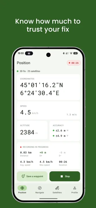
Coordinates in decimal degrees or DMS, geoid-corrected altitude using the EGM96 model, speed in km/h and m/s, horizontal and vertical accuracy with a colour indicator. You always know how much to trust your fix.
FULL SATELLITE VIEW
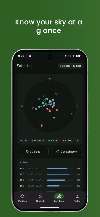
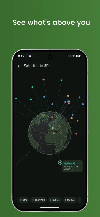
Every visible satellite listed, constellation by constellation. An azimuth and elevation sky plot. And a custom-built 3D globe showing the real geometry of the constellation above you: you finally see where your GNSS signals are coming from.
COMPASS
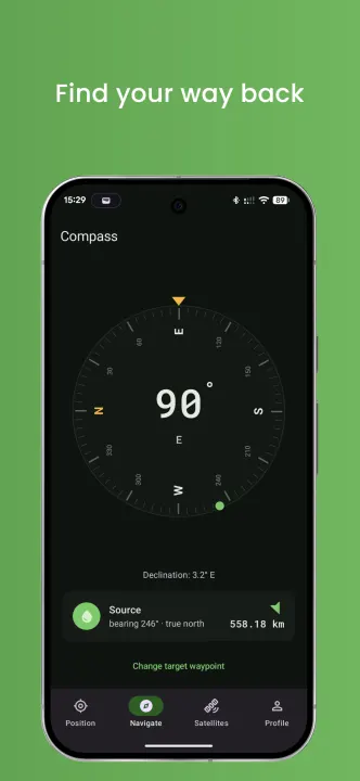
Heading dial referenced to magnetic or true north, your choice. Point-to-point navigation with arrow, distance and bearing to any waypoint you pick.
TRACK RECORDING
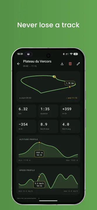
Start a session and put the phone back in your pocket. Distance covered, average and maximum speed, elevation gain and loss, minimum and maximum altitude.
WAYPOINTS
Mark what matters (water source, campsite, trailhead, etc.) with customizable icons. Every waypoint stays linked to the session it was dropped in.
TRIP LOG
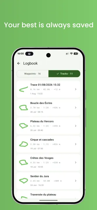
Browse all your past sessions with elevation profile, route trace and full statistics. GPX export so you can open your tracks anywhere.
ACHIEVEMENTS AND LEVELS
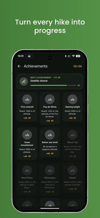
Over 25 achievements across families: altitude, from your first summit to Kilimanjaro. Speed. Simultaneous satellites. Total distance. Number of trips. Plus a few special ones: cross the 45th parallel north, get tracked on both sides of the equator, drop a waypoint before 6 a.m. Every achievement earns XP and levels you up, and your personal records carry over from trip to trip.
BUILT FOR THE OUTDOORS
Readable in direct sunlight, light and dark themes, controlled battery use, metric or imperial units, backup and restore of your data.
PLEASE NOTE
CairnGPS is a GNSS tool and a trip log, not a mapping app: it does not display a base map and does not calculate routes. It complements your map app rather than replacing it.
PERMISSIONS
Precise location is required, including in the background while a session is recording, so the app can keep following your route with the screen off. Recording never starts on its own: it begins only on an explicit action, and a persistent notification shows it at all times.
Watch the satellites that locate you in real time from all constellations on a 3D globe, a sky plot and a detailed list. Record your hikes, drop waypoints, unlock achievements.
The app reads your device's raw GPS through Android's own LocationManager rather than going through Google Play Services. It contains no Google libraries at all, needs no account and no network connection: everything works fully offline, and every position, track and waypoint stays on your phone.
REAL-TIME POSITION
Coordinates in decimal degrees or DMS, geoid-corrected altitude using the EGM96 model, speed in km/h and m/s, horizontal and vertical accuracy with a colour indicator. You always know how much to trust your fix.
FULL SATELLITE VIEW
Every visible satellite listed, constellation by constellation. An azimuth and elevation sky plot. And a custom-built 3D globe showing the real geometry of the constellation above you: you finally see where your GNSS signals are coming from.
COMPASS
Heading dial referenced to magnetic or true north, your choice. Point-to-point navigation with arrow, distance and bearing to any waypoint you pick.
TRACK RECORDING
Start a session and put the phone back in your pocket. Distance covered, average and maximum speed, elevation gain and loss, minimum and maximum altitude.
WAYPOINTS
Mark what matters (water source, campsite, trailhead, etc.) with customizable icons. Every waypoint stays linked to the session it was dropped in.
TRIP LOG
Browse all your past sessions with elevation profile, route trace and full statistics. GPX export so you can open your tracks anywhere.
ACHIEVEMENTS AND LEVELS
Over 25 achievements across families: altitude, from your first summit to Kilimanjaro. Speed. Simultaneous satellites. Total distance. Number of trips. Plus a few special ones: cross the 45th parallel north, get tracked on both sides of the equator, drop a waypoint before 6 a.m. Every achievement earns XP and levels you up, and your personal records carry over from trip to trip.
BUILT FOR THE OUTDOORS
Readable in direct sunlight, light and dark themes, controlled battery use, metric or imperial units, backup and restore of your data.
PLEASE NOTE
CairnGPS is a GNSS tool and a trip log, not a mapping app: it does not display a base map and does not calculate routes. It complements your map app rather than replacing it.
PERMISSIONS
Precise location is required, including in the background while a session is recording, so the app can keep following your route with the screen off. Recording never starts on its own: it begins only on an explicit action, and a persistent notification shows it at all times.
All versions
| Version | Released | Minimum Android | Size |
|---|---|---|---|
| 1.3.0 | Nov 4, 2026 | Android 8.0 | 3 MB |
| 1.2.0 | Oct 31, 2026 | Android 8.0 | 3 MB |
| 1.1.1 | Oct 25, 2026 | Android 8.0 | 2.9 MB |
| 1.1.0 | Oct 15, 2026 | Android 8.0 | 2.9 MB |
How to install an older version of an Android app · How to install an APK file on Android
From the developer (GitHub)
APK files published by the developer on GitHub. They are signed by the developer and may not install over the other builds on this page (different signature). Links open github.com.
Similar apps
-
 openScale
Weight and body metrics tracker, with support for Bluetooth scales
-
 Food You - Calorie Tracker & Food Diary
Track your calories with Material You aesthetic
-
 OpenTracks (Non-reproducible)
A sport tracker buddy that respects your privacy.
-
 OpenTracks (Reproducible build)
A sport tracker buddy that respects your privacy.
-
 RailTrip
Travel through the train stations to stamp your visa!
-
 Tower Collector
Join the community and collect cell towers locations from your area!
-
 OsmAnd~
Global Mobile Map Viewing & Navigation for Offline and Online OSM Maps
-
 OpenBeautyFacts
Look up cosmetic